Welcome To
Everett-Stewart Regional Airport
Everett-Stewart Regional Airport is a professionally operated regional airport, with a full-service Fixed Base Operation (FBO) and competitive prices. The airport is located in Union City, TN in Northwest Tennessee. The airport offers a professionally trained staff and provides all the amenities of a large airport without the hassle. Our goal is to make each customer feel special and enjoy their time here in Union City TN.

At Everett-Stewart Regional Airport, we offer a full range of services:
- Fuel (100LL & Jet-A), self-serve fueling available & Jet A Truck on request for quick turns.
- Ground Transportation (Courtesy Car & Enterprise Car Rental)
- Wireless Internet
- Catering
- Hotel Accommodations reservations
- Freight Delivery (Air/Ground)
- Leasing
- Flight Planning room with weather
- Flight Training
- Airframe Maintenance
- Line Services
- Rental
Airport Information
| Lat/Long |
36-22-54.4500N/ 088-59-07.5150W 36-22.907500N / 088-59.125250W 36.3817917 / -88.9854208 (estimated) |
| Elevation | 335 ft. / 102.1 m (surveyed) |
| Variation | 00E (2000) |
| From City | 4 Miles SE of Union City, TN |
| Zip Code | 38261 |
| Airport Use | St. Louis |
| Control Tower | No |
| ARTCC | Memphis Center |
| FSS Jackson FLight Service Station | (866) 840-1051 |
| NOTAMs | Facility MKL (NOTAM-D service available) |
| Attendance | Daylight Hours |
| Wind Indicator | Lighted |
| Segmented Circle | Yes |
| Lights | Dusk-Dawn |
| ACTVT | ODALS RY 01 – CTAF |
| TCA/UNICOM | 122.7 |
| WX AWOS-3 | 139.325 (731) 885-9161 |
| After Hour Access |
Gate and Terminal Entrance after-hours access code– AWOS preceded by |
Runway Information
| Dimensions | 6503 x 100 ft. / 1982 x 30 m |
| Surface | Asphalt, in good condition |
| Weight Limitations |
Single Wheel: 45,000 lbs Double Wheel: 60,000 lbs |
| Runway Edge Limits | Medium Intensity |
| Gradient | Medium Intensity |
| Gradient |
RY 01 Slope 0.53% Down North Ry 19 Slope 0.53% Up South |
| Runway 1 | Runway 2 | |
| Latitude | 36-22.498000N | 36-23.317000N |
| Longitude | 088-59.18133W | 088-59.068667W |
| Elevation | 335.4 ft | 308.8 ft |
| Traffic Pattern | Left if SFC Winds favor RY 01, Right TFC for that RY is in effect when Aerobatic Area is active. | Left |
| Runway Heading | 006 | 186 |
| Markings | Nonprecision, in good condition | Nonprecision, in good condition |
| Visual Slope Indicator | 4-light PAPI on left (3.00 degrees glide path) PAPI OTS INDEFLY | 4-light PAPI on left (3.00 degrees glide path) |
| Approach Lights | ODALS: omnidirectional approach lighting system | |
| Runway End Identifier Lights | yes | yes |
| Instruments Approach | ILS | GPS |
| Obstructions | 55 ft. Silo, 2759 ft. from runway, 115 ft. left of centerline, 46:1 slope to clear Dirt Road Crosses L to R of Clear Zone 560 ft S of THR |
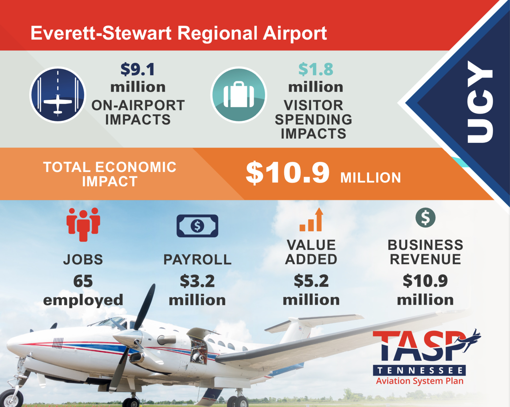
Economic Impact
Nearby Airports
TGC – Gibson County Airport – 28 nm S
PHT – Henry County Airport – 29 nm E
M25 – Mayfield Graves County Airport – 3 nm NE
DYR – Dyersburg Municipal Airport – 31 nm SW
HZD – Carroll County Airport – 31 nm SE